
The Road Less Travelled
For the most up to date information on the Doring River crossing conditions please click here to scroll to the bottom of this post
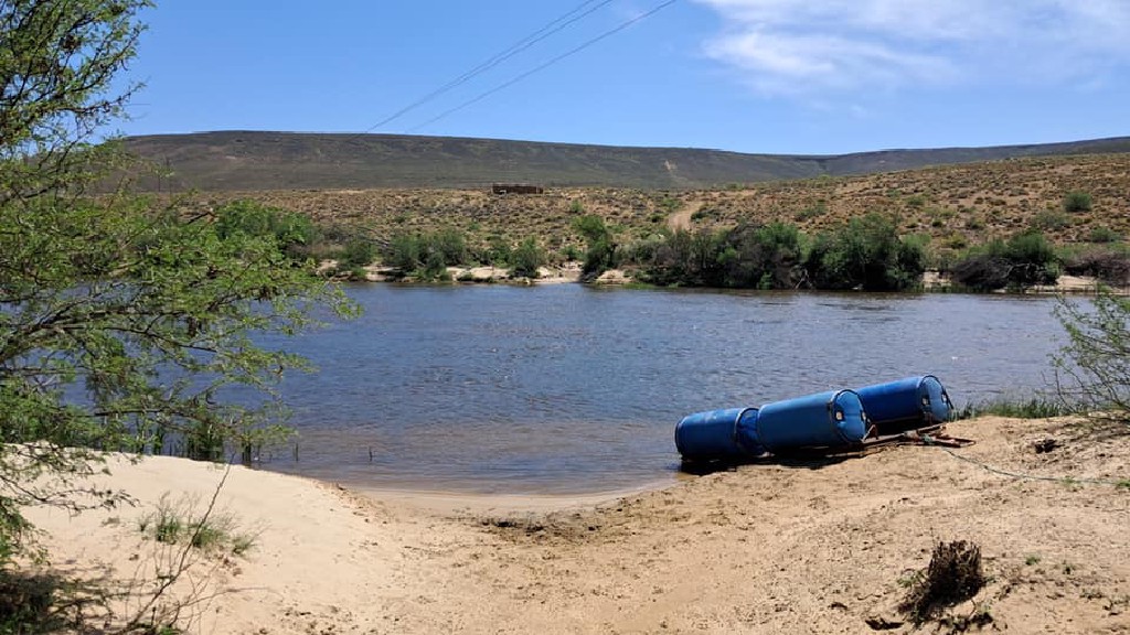
There’s something rather romantic about the name Uitspankraal, though if you find yourself standing on the banks of the Doring River at this remote spot in the Biedouw Valley, romance might be the furthest thing from your mind. This is where the hardy souls with their 4x4s and adventure bikes come to cross the Doring - a straightforward enough proposition when the river is low or dry and there’s only thick sand to negotiate, but one that becomes a serious test of nerve when there’s just enough water to stress you out by washing over your bonnet. When it’s running deep or in flood, of course, crossing becomes impossible altogether.
You’ll find this crossing at the confluence of the Doring and Biedouw rivers, right where the Western Cape bumps up against the Northern Cape. It’s the sort of place that feels like the edge of the world - which, in many ways, it is. The nearest tar road is a good 45 kilometres away through the scenic but remote Biedouw Valley, but you’re not entirely alone out here thanks to Kyle and his father Leon at Jai Yen Yen, just up the hill from the crossing.
When the Pioneers Came This Way
The name tells you everything you need to know about this place. “Uitspan” harks back to the days of ox-wagons, when drivers would outspan their weary beasts after a hard day’s slog across the veld. The oxen would graze while the people rested, and when it was time to move on, they’d span up again and tackle whatever lay ahead. These days, it’s 4x4 drivers and bikers who need to rest and gather their courage before taking on the Doring River crossing.
At Uitspankraal today, you’ll find the little oasis that is Jai Yen Yen - an unexpected delight with camping, a swimming pool, and a licensed pub, perfect for contemplating what lies ahead, or to celebrate what you’ve just accomplished, depending on which direction you’re traveling.
The Reality of the Crossing
Let’s not mince words: when the Doring is running with enough water to make things interesting, this is no place for the faint-hearted or inexperienced. The Doring River here runs about 80 metres wide, and while it might look deceptively shallow from the bank, it has a nasty habit of suddenly dropping to over a metre deep right when you think you’re in the clear. More than one confident driver has found themselves with water washing over their bonnet, cursing themselves for not walking the entire crossing first.
The good news is that when conditions are right - typically from October through to May - the crossing is entirely doable for a properly equipped 4x4 with an experienced driver. The river bottom is sandy rather than muddy, which gives decent traction, though it’s strewn with boulders that can be shifted around by strong flood waters. Fortunately, as soon as the water levels drop, Kyle is down in the river moving the boulders out of the way to create a perfect track across again.
For those on adventure bikes, there’s the SAS ‘Wilde Hond’ (Wild Dog) on the river bank - Jai Yen Yen’s pontoon built from a grid and a couple of large water barrels that can carry a single motorcycle. It’s been known to spring leaks and require field repairs, and getting two bikes across can get you very wet and take the better part of three hours. But then again, if you’re the sort of person who rides an adventure bike to places like this, then this probably doesn’t faze you.
Seasonal Considerations
The Biedouw Valley is at its most spectacular between August and September when the spring flowers carpet the valley floor in a riot of colour. It’s also when the Doring River is most likely to be impassable, swollen by winter rains.
From June through November, you might as well not bother trying. The locals will tell you that with a knowing smile, and they’re worth listening to. Kyle at the bush pub is your best bet for current conditions via WhatsApp only - there’s no cellular reception in the valley itself (scroll to the bottom of the page for details). You can also phone us here at Enjo for local advice. We will try to keep a section at the bottom of this blog post updated with current crossing news and information and with a link to Jai Yen Yen’s Facebook page.
What You Need to Know
If you’re planning to tackle this crossing when there’s water, you’ll need a 4x4. Before you even think about entering the water, walk the entire crossing. Yes, all 80 metres of it. Take your boots off if you must, but check every metre of that route. Pay particular attention to the small dog leg on the northern side between the boulders - it’s best to walk this section to get an idea of where the sandy track through the river runs if you can’t see it clearly through the water. The deepest section lurks around the halfway point, just waiting to catch the overconfident.
The approaches to the crossing have their own challenges. Coming from the Enjo side through the Biedouw Valley, you’ll pass through numerous farm gates (remember to close them behind you). The road can get steadily rougher as you approach the crossing, especially if it hasn’t been graded for months and there’s been adverse weather which sometimes washes parts of the road away. Approaching from the Tankwa Karoo side, the road is very rough, especially the last 15 kilometres or so after passing Dassieskloof farm, and will test your resolve as you’ll have to slow down considerably for at least the last 15 kilometres before the river crossing. There are some steep gradients and then a descent down to the river from the gate at the Western Cape border.
The Bigger Picture
This crossing connects the Biedouw Valley with the R355 north of the Tankwa Karoo National Park. It’s a route that requires good preparation and careful planning.
If you do make it across, you’ll have tackled a memorable crossing in a beautiful part of the world. If you don’t - if the river is too high, or your nerve fails you, or mechanical problems intervene - well, that’s part of the adventure too. Sometimes the journey is about knowing when to turn back, and there’s no shame in that.
The Doring River will be here tomorrow, and the day after that. It’s been flowing through this valley for millennia, and it’s not going anywhere. Neither, for that matter, is the sense of achievement that comes from successfully crossing it when conditions are right and you’re properly prepared.
Just remember to close the gates behind you.
Useful Info
Latest Update (9 June 2025): The Doring River is currently in flood after heavy rainfall fell upstream over the weekend (7-8 June). At this point in time is unknown when crossing will again be possible.
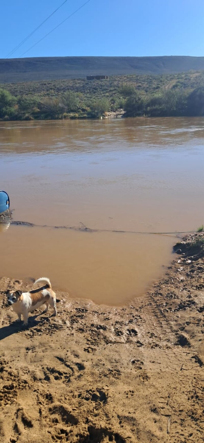 Doring River in flood at the Biedouw valley crossing - 9 June 2025 - photo courtesy of Kyle at Jai Yen Yen
For current river conditions, contact Kyle at Jai Yen Yen on 072 342 6632 (WhatsApp only) or us at Enjo Nature Farm. No cellular coverage available in the valley - plan accordingly.
- Enjo to Die Bos on the R355 - Map and Directions - Our map of the route
- Jai Yen Yen Facebook Page - For current crossing conditions and updates
Comments